
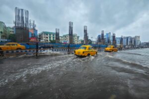
On March 31, 2025, the Indian government closed out its Smart Cities Mission. Over a decade, the project channeled ₹1.5 trillion ($16 billion) into upgrading 100 urban centers. Municipalities installed 84,000 CCTV cameras, digitized utility networks, and built Integrated Command and Control Centres to monitor civic data. But when the intense monsoons of mid-2026 arrived, those same control rooms were reduced to broadcasting high-definition footage of their own submerged arterial roads and paralyzed tech parks across Bengaluru, Mumbai, and the National Capital Region.
India spent a decade and $16 billion digitizing the surface of its cities while actively dismantling the hydrology beneath them.
City planners and developers have systematically paved wetlands, filled lakes, and poured concrete over historical floodplains. According to structural audits on urban drainage by the Comptroller and Auditor General (CAG) of India, sealing natural catchments multiplies flood peak volumes by up to eight times. Separately, the World Bank’s Climate Change and Cities report identifies a secondary crisis: India is expanding its urban footprint directly into mapped floodplains faster than almost any other nation, placing millions of residents squarely in the path of this amplified runoff.
Climate change accelerates this planning failure. Data from the Ministry of Earth Sciences’ Assessment of Climate Change over the Indian Region shows that the frequency of heavy rainfall events—specifically those exceeding 100 mm in 24 hours—has jumped by more than 50 percent across central and southern India over the last five decades. This translates to highly concentrated deluges, such as the 160 mm dumped on Mumbai’s eastern suburbs in just four hours in late June 2026. Because the paved earth cannot absorb water at this speed, the entire runoff volume is forced into underground stormwater drains never built for this intensity of rainfall. Municipalities cannot simply dig their way out of this; upgrading aging pipe networks in densely packed historical neighborhoods requires mass demolitions and complex land acquisition battles that local governments actively avoid.
In 2025, Gurugram accounted for 53 percent of all housing launches in the National Capital Region. In new sectors along the Dwarka Expressway, developers launch luxury apartments starting at ₹10 crore. Yet, the Central Ground Water Board officially classifies the district’s water extraction as “over-exploited.” Property consultancies like Anarock now warn buyers to verify if their luxury towers rely entirely on private diesel water tankers. This scarcity is a direct consequence of surface sealing. A TERI (The Energy and Resources Institute) water-sustainability assessment found that Gurugram’s water-body area shrank from roughly 55 sq km to just 12 sq km over a decade, destroying the percolation zones required to capture rainwater and recharge aquifers. When 82 mm of rain fell in just a few hours on July 7, 2026, the terrain could not absorb it. Arterial roads transformed into rivers, traffic stalled across the city, and Gurugram Police were forced to issue formal work-from-home advisories to the corporate workforce.
Mumbai’s premium business district, the Bandra-Kurla Complex (BKC), was built directly over the Mithi River’s mangrove swamps—wetlands designed by nature to absorb tidal surges. Today, the ongoing Coastal Road project threatens thousands of remaining mangroves. The city’s multi-crore BRIMSTOWAD stormwater drainage project is severely compromised by this geography. A CAG audit revealed that of Mumbai’s 45 major drainage outfalls discharging rainwater into the sea, only three were fitted with floodgates. If heavy rain coincides with high tide, the ocean flows directly backward into the streets. The result is chronic paralysis: on June 29, 2026, a sudden downpour submerged the Andheri subway and chronic flooding spots across the suburbs, halting the city’s vehicular movement in hours.
Over the last two decades, Chennai’s IT corridors and residential zones rapidly encroached on the Pallikaranai marshland and historical riverbanks. During Cyclone Michaung in December 2023, the water reclaimed its historical basin. The airport shut down, manufacturing operations halted, and the state recorded economic losses exceeding ₹11,000 crore ($1.32 billion) in a matter of days. In lower-income areas, floodwaters regularly breach informal settlements and mix directly with raw sewage from illegal drain connections, destroying ground-floor homes.
A similar financial hit paralyzed Bengaluru’s Outer Ring Road (ORR) tech corridor on August 30, 2022. The Outer Ring Road Companies Association (ORRCA) formally reported a productivity loss of ₹225 crore ($27 million) in a single day as IT parks lost power and employees spent five hours stranded in traffic. This was not merely a volume issue; it was a topographic failure. Municipal valley studies from the Bruhat Bengaluru Mahanagara Palike (BBMP) and independent urban planners have long documented how the ORR was built directly across the natural gradients of the Koramangala-Challaghatta valley, effectively acting as a dam. When extreme rain hits, the paved infrastructure blocks water from following its historical path to Bellandur Lake, turning the ring road into a stagnant reservoir.
Faced with arterial flooding that halts entire tech corridors, municipalities are beginning to experiment with localized permeability initiatives. In its March 2026 budget, the newly formed Bengaluru Central City Corporation (BCCC) announced a shift toward “sandless asphalt” for pedestrian footpaths. By removing sand from the mix, the pavement becomes porous, allowing water to seep into an underlying stone drainage system.
This implementation faces severe friction. In dust-heavy Indian environments, porous asphalt clogs with silt within months. Unless municipalities invest heavily in specialized vacuum-sweeping fleets, the expensive porous pavements quickly revert to impermeable concrete.
The penalty for ignoring local geology is shifting from commuter inconvenience to hard financial risk. While global institutional investors and commercial property insurers have long priced climate resilience into coastal American and European real estate, this framework is just beginning to emerge for Indian tech hubs. In a recent report on climate risks to Indian real estate, property consultancy Knight Frank noted that developers and investors are increasingly forced to factor flood vulnerability into project viability and prime office rent yields. If cities cannot manage their own drainage, the inevitable next step is downgraded municipal bonds and surging commercial insurance premiums for their flagship tech parks. The transition from ecological loss to economic penalty has firmly begun.
Sources Consulted:
- India Brand Equity Foundation (IBEF) / Smart Cities Mission Data: Final mission timelines, budget outlays (₹1.5 trillion), and project completion statistics.
- TERI (The Energy and Resources Institute) / Central Ground Water Board: Data on Gurugram’s “over-exploited” groundwater status and the systemic loss of natural water bodies (from roughly 55 sq km to 12 sq km).
- BusinessWorld / Anarock: Gurugram real estate metrics (53% NCR housing launch share), luxury pricing, and residential water reliance trends.
- Ministry of Earth Sciences / IMD: Assessment of Climate Change over the Indian Region report, detailing the >50% increase in extreme rainfall events; recent June/July 2026 precipitation data including Gurugram’s 82 mm record.
- Comptroller and Auditor General (CAG) of India: Performance audits on Mumbai’s BRIMSTOWAD stormwater management, floodgate deficiencies (3 of 45), and the 8x multiplier in flood peak volumes due to urbanization.
- Government of Tamil Nadu / NDMA: Cyclone Michaung (2023) economic loss estimates (₹11,000 crore) and infrastructure damages.
- Outer Ring Road Companies Association (ORRCA) / BBMP Valley Studies: Formal communications detailing the ₹225 crore single-day productivity loss during the August 30, 2022 floods, and urban planning documentation of the Koramangala-Challaghatta valley gradient blockage.
- The Times of India / OpenCity Data: BCCC March 2026 infrastructure budget, “sandless asphalt” initiatives, and statements by municipal commissioners following the 2025 BBMP restructuring.
- World Bank / Knight Frank: Climate Change and Cities report, tracking the rapid expansion of Indian urban settlements into flood-prone areas, and consultancy reports on emerging climate risk pricing in Indian real estate.
